
- Nautical Jewelry
- Caribbean Hook Bracelets
- Destination Bracelets - USA / Caribbean Popular Locations
- 14K Gold/Silver Caribbean U Hook Bracelets Sterling Silver & Gold
- Caribbean Hammered Finish Hook Bracelets
- Caribbean Anchor Hook Bracelet - Sterling Silver & 14K Gold
- Caribbean Fish Hook Bracelet - Sterling Silver & 14K Gold
- Turtle Hook Bracelet - Sterling Silver & 14K Gold
- Biker Hook Bracelet - Sterling Silver & 14K Gold
- Pirate Hook Bracelet - Sterling Silver & 14K Gold
- Shark Hook Bracelet - Sterling Silver & 14K Gold
- Golf Hook Bracelet - Sterling Silver & 14K Gold
- Opal Inlay Hook Bracelet - Sterling Silver & 14K Gold
- Palm Hook Bracelet - Sterling Silver & 14K Gold
- Caribbean Hook Pineapple Bracelet - Sterling Silver & 14K Gold
- Marlin Hook Bracelet - Sterling Silver & 14K Gold
- Knot Hook Bracelet - Sterling Silver & 14K Gold
- Equestrian Hook Bracelet - Sterling Silver & 14K Gold
- Gator Hook Bracelet - Sterling Silver & 14K Gold
- Sting Ray Hook Bracelet - Sterling Silver 14K Gold
- Whale Tale Hook Bracelet - Sterling Silver & 14K Gold
- Divi Divi Hook Bracelet - Sterling Silver & 14K Gold
- Lobster Hook Bracelet - Sterling Silver & 14K Gold
- Gift Hook Bracelet - Sterling Silver & 14K Gold
- Mermaid Hook Bracelet - Sterling Silver & 14K Gold
- Black Titanium Hook Bracelet - Sterling Silver & 14K Gold
- Scallop Hook Bracelet - Sterling Silver & 14K Gold
- Hurricane Hook Bracelet - Sterling Silver & 14K Gold
- Shared Moments Hook Bracelet - Sterling Silver & Yellow Gold
- Compass Rose Hook Bracelet - Sterling Silver & 14K Gold
- Seahorse Hook Bracelet - Sterling Silver & 14K Gold
- Caribbean Mariners Heart Hook Bracelet - Sterling Silver & 14K Gold
- Caribbean Hook Cable Bracelet - Sterling Silver & 14K Gold
- Caribbean Hibiscus Bracelet - Sterling Silver & 14K Gold
- Caribbean Hook Sand Dollar Bracelet - Sterling Silver & 14K Gold
- Caribbean Shackle Hook Bracelet - Sterling Silver & 14K Gold
- Larimar Mines Collection Caribbean Bracelet - Sterling Silver & 14K Gold
- Unity Hook Bracelet - Sterling Silver & 14K Gold
- Caribbean Double Flip Flop Hook Bracelet - Sterling Silver & 14K Gold
- Caribbean Lizard Hook Bracelet - Sterling Silver & 14K Gold
- Dragonfly Hook Bracelet - Sterling Silver & 14K Gold
- Caribbean Dolphin Hook Bracelet - Sterling Silver & 14K Gold
- Caribbean Hook Link Bracelet - Sterling Silver & 14K Gold
- Petroglyph Hook Bracelet - Sterling Silver & 14K Gold
- Awareness Hook Bracelet - Sterling Silver & 14K Gold
- Eco Hook Bracelet - Sterling Silver & 14K Gold
- Totem Pole Hook Bracelet - Sterling Silver & 14K Gold
- Treasure Coin Bracelet - Sterling Silver & 14K Gold
- Mahi Mahi Hook Bracelet - Sterling Silver & 14K Gold
- Caribbean Clasp Bracelet - Sterling Silver & 14K Gold
- Scallop and Sand Dollar Hook Bracelet - Sterling Silver & 14K Gold
- Lovers Loop Hook Bracelet - Sterling Silver & 14K Yellow Gold
- Carribbean Heart Hook Bracelet - Sterling Silver & 14K Gold
- Fleur De Lis Hook Bracelet - Sterling Silver & 14K Gold
- Frog Hook Bracelet - Sterling Silver & 14K Gold
- Racing Hook Bracelet - Sterling Silver 14K Gold
- Caribbean Bracelet or Ring Exchange
- Caribbean Mesh Hook Bracelets
- Dolphin Heart Hook Bracelet W/imi Opal
- Sailors Knot Hook Bracelet
- Treasure Coin Hook Bracelet - Sterling Silver 14K Gold
- Friendship Hook Bracelets
- Baseball Hook Bracelets
- Butterfly Hook Bracelets
- Dolphin Wave Bracelet W/Sterling Silver 14Ky Wrap
- Double Wave Bracelet W/Wraps
- Whale Tail Wave Bracelet W/plain Bar Sterling Silver Wraps
- Sterling Silver Tennis Bracelet
- Sterling Silver Soccer Bracelet W/14ky Wraps
- Sterling Silver 6mm Football Bracelet
- Wave Chain Cuff Bracelet W/ajustable Closing Sterling Silver 14ky Wraps
- Port Hook Bracelets
- Long Wave Bracelet W/Sterling Silver 14ky Wrap
- Silhouette Bracelets With Sterling Silver 14ky Wrap
- Starfish Bracelet W/Sterling Silver 14ky Wrap
- Palm Moon Hook Bracelets
- Peace Bracelets With Sterling Silver 14ky Wraps
- Ancient Turtle Coin Two Tone Bracelet
- Caribbean Hook Bracelet Matching Earrings
- Esprit Bracelets
- Destination Jewelry Brand Mar Azul Jewelry
- Caribbean Hook Rings - Sterling Silver & 14K Gold
- Caribbean Hook Pendants
- Destination Bracelets - USA / Caribbean Popular Locations
- The Original Hook Bracelet
- Peter Costello Nautical Jewelry
- Nautical Saltwater Gamefish Pendants
- 14K Gold Nautical Offshore Sportsfish Pendants
- 14K Gold Nautical Earrings
- 14K Gold Nautical Sea Life Pendants
- Nautical Shallow Water Pendants
- 14k Gold Nautical Bracelets
- Gold Nautical Wings To Whales Pendants - Earrings
- 14K Gold Nautical Aquatic Adorables Jewelry
- 14k Gold Tournament Time Collections
- 14K Gold Nautical Silhouette Pendants
- 14K Gold Nautical Rings
- Nautical Bangles
- Nautical Slides
- Gold Sealife Earrings
- 14K Gold Nautical Treasured Tropical Pendants
- Classic of New York Jewelry
- Classic of New York Nautical Jewelry
- Classic of New York Nautical Larimar Jewelry
- Classic Of New York Earrings
- Classic Of New York Necklaces
- Classic Of New York Rings
- Classic Of New York Bracelets
- Classic Of New York Pendants
- Classic Of New York Chains
- Classic Of New York Anklets
- Classic Of New York Cufflinks
- Classic Of New York Pre Packaged Collections
- Classic Of New York Sets
- Dazzlers Fine jewelry
- 14K Gold Sports Charms
- Bracelets - Gold Bracelets, Silver Bracelets, Caribbean Bracelets, Marine Life Bracelets
- Earrings - Gold Earrings, Silver Earrings, Pearl Earrings, Marine Life Earrings
- Necklaces - Gold|Silver
- Pendants - Gold Silver Jewelry Pendants
- Dazzlers Premium Gold Charms for Bracelets
- Dazzlers Mens Gold Rings
- Dazzlers Ladies Gold Rings
- Caribbean Hook Bracelets
- Recreational Boating
- Boat Lights - Marine LED Lights / Halogen Lighting
- Marine Interior Boat Downlights
- Marine Reading & Chart Lights
- Marine Interior Wall Lights
- Marine Low Intensity Courtesy Lights
- Marine LED Table Lamps
- Marine Engine Room & Utility Marine - Boat Lights
- Marine Boat Deck Lighting - Cockpit Floodlights
- Marine Boat Lights Fluorescents & Linear LED
- Marine Boat LED Replacement Bulbs
- Lumishore Underwater LED Boat Lights
- Lumishore HD Underwater Cameras
- Straight & Curved Marine LED Bar Lights
- Boat Navigation Lights - DHR LED Commercial Marine
- Marine LED Converters for LED Boat Lights
- Marine Boat Light Parts & Accessories
- Marine Flexible LED Strips - Rope Lights
- Lux Lighting Strip Lights and Controls
- Marine Lamps and Holders
- Underwater LED Boat Lights
- Emergency Lights
- Marine Electric Switches, Dimmers, Outlets, Sockets, Transformers
- Vimar Marine Idea Switches, Idea Outlets, Idea Dimmers, Idea Cover Plates
- Vimar Eikon Switches, Eikon Dimmers, Eikon Outlets
- Transformers & Converters
- Vimar Marine Arke Switches, Arke Outlets, Arke Dimmers, Arke Cover Plates
- Vimar Marine Switches, Plugs, Outlets, Dimmers, Adapters, Cover Plates
- Vimar Arke USB Charging Outlets
- Rechargeable Batteries
- Victron Energy
- Victron Transformers
- Windlass Lofrans - Muir Marine Anchoring Systems for Boats
- Lofrans Windlass Marine Anchor Systems for Boats
- Muir Windlass Marine Anchor Systems for Boats
- AutoAnchor
- Switchgear
- Anchor Chain, Line and Rodes
- Marine Anchor Bow Rollers for Boats
- Marine Anchor Accessories for Boats
- Motor Cooling Fans
- Electrical Switchgear
- Sleipner Windlass Marine Anchor Systems for Boats
- Marine Potable Water Tanks
- Marine Outboard - Waste Holding Tanks- Diesel Tanks
- Marine Windshield Wipers - Wiper Motors
- Marine Wiper Blades
- Exalto Type 1 - Type 1.5 Exalto Type 1 - 1.5 Fixed Length Marine Wiper Arms Boat Marine Windshield Wipers -Motors - Blades
- Exalto Type 2 and 3 Boat Windshield Wipers -Motors - Blades
- W25 Series Boat Windshield Wipers - Motors - Blades
- W38 Series Boat Windshield Wipers -Motors - Blades
- W50 Series Wiper Motors - Blades
- Coastal Series Boat Marine Windshield Wiper -Motors - Blades
- W12 Series Wiper Motors
- Marine Wiper Controls
- Marine Wiper Washing Systems
- Marine Wiper System Spare Parts - Accessories
- Roca Wiper Motors
- Exalto Marine Wiper Motors
- Marine Galley Fresh Water Pumps
- NorSap Adjustable Boat Table Pedestals
- NorSap Boat Seat Pedestals
- Imtra Marine Access Boat Hatches / Handrails
- Bow Thrusters - Side-Power Thruster Systems for Boats
- Bow Thrusters for Boats - Side Power Marine DC Electric
- Side-Power Marine Hydraulic Bow or Stern Thrusters for Boats
- Side Power External Single Bow Thrusters
- Side-Power Stern Thruster - SX Series External Thrusters
- Side-Power SR/SRP Series Retracting Thruster
- Side-Power Controls and Accessories
- Side-Power Parts and Upgrade Kits
- Side-Power S-link Cable Parts
- Side-Power Composite Bow Thruster Propeller Blades, Kits
- Q-Prop Upgrade Kit
- Side-Power Cowlings For Stern Tunnel
- Side-Power Bow Thruster - Bow Tunnels
- Side-Power Stern Tunnels/Grids
- Side Power Aluminum Bow Tunnel
- Side Power Bow Tunnel, Steel
- Side Power Install Kits
- Side-Power Installation Tools
- Side-Power SRL/SRLP Series Retractable Thruster
- Side-Power SRV/SRVP Series Retracting Thruster
- External Dual Bow Thruster
- Side-Power External Oil Coolers
- Side-Power Filter Elements
- Side-Power Gear Leg Assembly
- Side-Power Motor Assembly, Kits
- Side-Power Motors Brush, Holder Springs
- Side-Power Motors Solenoids, Solenoid Assembly Set
- Side-Power Motors Thermo Switches
- Side-Power Stabilizers and Parts
- Side-Power Valves and Components
- Side-Power SRH/SRHP Series Retracting Thruster
- Side-Power Bronze Thruster Propeller Blades, Kits
- Side-Power Marine Hydraulic Components
- Tool Kit
- Bow Thrusters for Boats - Side Power Marine AC Electric
- Side-Power E-series Thrusters
- Zipwake Interceptors Trim Control Systems for Boats
- Zipwake S Series S Starter Kits - Dynamic Trim-control System
- Zipwake Series E Starter Kits - Dynamic Trim-control System
- Zipwake Dynamic Trim Control - Control Panels & Covers
- Zipwake Chine Interceptors - Tunnel interceptors
- Zipwake Distribution Units
- Zipwake Cables Parts & Accessories
- Zipwake Interceptors Series S Cable & Cover
- Zipwake M12 Extension Cables
- Zipwake Interceptor Front Plates / Back Plates / Set Screws
- Zipwake Interceptors Series E Cable Cover
- Zipwake Control Panel Frames
- Zipwake Integration Kit
- MFD Integrator Modules
- Zipwake Drill Templates
- NorSap Boat Seat Helm Chairs
- Marine Portable Gas Tanks
- Norsap Boat Seat
- Insulation System
- KPM Boat Seat/ Accessories
- Rakego Folding Bracket, Hinges
- KPM Marine Systems and Accessories
- Boat Lights - Marine LED Lights / Halogen Lighting
- Clocks & Weather Stations
- Weems Plath Quick Ship In Stock Items
- Maximum Weather Stations & Instruments
- Maximum Time and Tide Clocks
- Maximum Wind Speed Direction Instruments, Wind Gauges
- Maximum Temperature Instruments, Thermometers
- Maximum Barometric Pressure Instruments, Barometers
- Maximum Relative Humidity Weather Instruments
- Maximum Rainfall Monitoring Instruments
- Maximum Panel Mounted Wired Weather Stations
- Maximum Weather Instruments Parts and Accessories
- Maximum Panel Mounted Wifi Weather Stations
- Weems & Plath Anniversary Clock, Barometer Collection
- Weems & Plath Navigation Plotter, Scope, Sextant, Chart Light Collection
- Weems & Plath Compasses
- Weems & Plath Binoculars Collection
- Weems & Plath Nautical Lights Collection
- Weems & Plath General Charts
- Personal Rescue Strobe
- Weems & Plath Books and Log Books
- Weems & Plath Bells Collection
- Weems & Plath Chart Weights and Magnifiers
- Weems & Plath Clocks
- Weems & Plath Thermometer Collection
- Weems & Plath Accessories
- Weems & Plath Barometer Parts and Accessories
- Weems & Plath Lights and Lamps Accessories
- Weems & Plath General Charts Parts & Accessories
- Weems & Plath Compasses Accessories
- Weems & Plath Clocks Parts & Accessories
- Weems & Plath Books & Log Books Accessories
- Weems & Plath Chart Light Accessories
- Other Accessories
- Weems & Plath LED Navigation Lights
- Weems & Plath Endurance Collection Clock, Barometer, Comfortmeter, Thermometer
- Commercial
- Commercial Marine Boating Products
- Windlass Lofrans - Muir Marine Anchoring Systems for Boats
- Lofrans Windlass Marine Anchor Systems for Boats
- Muir Windlass Marine Anchor Systems for Boats
- AutoAnchor
- Switchgear
- Anchor Chain, Line and Rodes
- Marine Anchor Bow Rollers for Boats
- Marine Anchor Accessories for Boats
- Motor Cooling Fans
- Electrical Switchgear
- Sleipner Windlass Marine Anchor Systems for Boats
- Marine Windshield Wipers - Wiper Motors
- Marine Wiper Blades
- Exalto Type 1 - Type 1.5 Exalto Type 1 - 1.5 Fixed Length Marine Wiper Arms Boat Marine Windshield Wipers -Motors - Blades
- Exalto Type 2 and 3 Boat Windshield Wipers -Motors - Blades
- W25 Series Boat Windshield Wipers - Motors - Blades
- W38 Series Boat Windshield Wipers -Motors - Blades
- W50 Series Wiper Motors - Blades
- Coastal Series Boat Marine Windshield Wiper -Motors - Blades
- W12 Series Wiper Motors
- Marine Wiper Controls
- Marine Wiper Washing Systems
- Marine Wiper System Spare Parts - Accessories
- Roca Wiper Motors
- Exalto Marine Wiper Motors
- NorSap Boat Seat Helm Chairs
- Zipwake Interceptors Trim Control Systems for Boats
- Zipwake S Series S Starter Kits - Dynamic Trim-control System
- Zipwake Series E Starter Kits - Dynamic Trim-control System
- Zipwake Dynamic Trim Control - Control Panels & Covers
- Zipwake Chine Interceptors - Tunnel interceptors
- Zipwake Distribution Units
- Zipwake Cables Parts & Accessories
- Zipwake Interceptors Series S Cable & Cover
- Zipwake M12 Extension Cables
- Zipwake Interceptor Front Plates / Back Plates / Set Screws
- Zipwake Interceptors Series E Cable Cover
- Zipwake Control Panel Frames
- Zipwake Integration Kit
- MFD Integrator Modules
- Zipwake Drill Templates
- Bow Thrusters - Side-Power Thruster Systems for Boats
- Bow Thrusters for Boats - Side Power Marine DC Electric
- Side-Power Marine Hydraulic Bow or Stern Thrusters for Boats
- Side Power External Single Bow Thrusters
- Side-Power Stern Thruster - SX Series External Thrusters
- Side-Power SR/SRP Series Retracting Thruster
- Side-Power Controls and Accessories
- Side-Power Parts and Upgrade Kits
- Side-Power S-link Cable Parts
- Side-Power Composite Bow Thruster Propeller Blades, Kits
- Q-Prop Upgrade Kit
- Side-Power Cowlings For Stern Tunnel
- Side-Power Bow Thruster - Bow Tunnels
- Side-Power Stern Tunnels/Grids
- Side Power Aluminum Bow Tunnel
- Side Power Bow Tunnel, Steel
- Side Power Install Kits
- Side-Power Installation Tools
- Side-Power SRL/SRLP Series Retractable Thruster
- Side-Power SRV/SRVP Series Retracting Thruster
- External Dual Bow Thruster
- Side-Power External Oil Coolers
- Side-Power Filter Elements
- Side-Power Gear Leg Assembly
- Side-Power Motor Assembly, Kits
- Side-Power Motors Brush, Holder Springs
- Side-Power Motors Solenoids, Solenoid Assembly Set
- Side-Power Motors Thermo Switches
- Side-Power Stabilizers and Parts
- Side-Power Valves and Components
- Side-Power SRH/SRHP Series Retracting Thruster
- Side-Power Bronze Thruster Propeller Blades, Kits
- Side-Power Marine Hydraulic Components
- Tool Kit
- Bow Thrusters for Boats - Side Power Marine AC Electric
- Side-Power E-series Thrusters
- Land Based
- Land Based Commercial Work Vehicle Products
- NorSap Adjustable Boat Table Pedestals
- Marine Galley Fresh Water Pumps
- Boat Lights - Marine LED Lights / Halogen Lighting
- Marine Interior Boat Downlights
- Marine Reading & Chart Lights
- Marine Interior Wall Lights
- Marine Low Intensity Courtesy Lights
- Marine LED Table Lamps
- Marine Engine Room & Utility Marine - Boat Lights
- Marine Boat Deck Lighting - Cockpit Floodlights
- Marine Boat Lights Fluorescents & Linear LED
- Marine Boat LED Replacement Bulbs
- Lumishore Underwater LED Boat Lights
- Lumishore HD Underwater Cameras
- Straight & Curved Marine LED Bar Lights
- Boat Navigation Lights - DHR LED Commercial Marine
- Marine LED Converters for LED Boat Lights
- Marine Boat Light Parts & Accessories
- Marine Flexible LED Strips - Rope Lights
- Lux Lighting Strip Lights and Controls
- Marine Lamps and Holders
- Underwater LED Boat Lights
- Emergency Lights
- Marine Electric Switches, Dimmers, Outlets, Sockets, Transformers
- Vimar Marine Idea Switches, Idea Outlets, Idea Dimmers, Idea Cover Plates
- Vimar Eikon Switches, Eikon Dimmers, Eikon Outlets
- Transformers & Converters
- Vimar Marine Arke Switches, Arke Outlets, Arke Dimmers, Arke Cover Plates
- Vimar Marine Switches, Plugs, Outlets, Dimmers, Adapters, Cover Plates
- Vimar Arke USB Charging Outlets
- Rechargeable Batteries
- Victron Energy
- Victron Transformers
- Oil & Gas
- Oil & Gas Commercial Grade Products
- Marine Windshield Wipers - Wiper Motors
- Marine Wiper Blades
- Exalto Type 1 - Type 1.5 Exalto Type 1 - 1.5 Fixed Length Marine Wiper Arms Boat Marine Windshield Wipers -Motors - Blades
- Exalto Type 2 and 3 Boat Windshield Wipers -Motors - Blades
- W25 Series Boat Windshield Wipers - Motors - Blades
- W38 Series Boat Windshield Wipers -Motors - Blades
- W50 Series Wiper Motors - Blades
- Coastal Series Boat Marine Windshield Wiper -Motors - Blades
- W12 Series Wiper Motors
- Marine Wiper Controls
- Marine Wiper Washing Systems
- Marine Wiper System Spare Parts - Accessories
- Roca Wiper Motors
- Exalto Marine Wiper Motors
- NorSap Boat Seat Helm Chairs
- Boat Lights - Marine LED Lights / Halogen Lighting
- Marine Interior Boat Downlights
- Marine Reading & Chart Lights
- Marine Interior Wall Lights
- Marine Low Intensity Courtesy Lights
- Marine LED Table Lamps
- Marine Engine Room & Utility Marine - Boat Lights
- Marine Boat Deck Lighting - Cockpit Floodlights
- Marine Boat Lights Fluorescents & Linear LED
- Marine Boat LED Replacement Bulbs
- Lumishore Underwater LED Boat Lights
- Lumishore HD Underwater Cameras
- Straight & Curved Marine LED Bar Lights
- Boat Navigation Lights - DHR LED Commercial Marine
- Marine LED Converters for LED Boat Lights
- Marine Boat Light Parts & Accessories
- Marine Flexible LED Strips - Rope Lights
- Lux Lighting Strip Lights and Controls
- Marine Lamps and Holders
- Underwater LED Boat Lights
- Emergency Lights
- Maximum Weather Stations & Instruments
- Maximum Time and Tide Clocks
- Maximum Wind Speed Direction Instruments, Wind Gauges
- Maximum Temperature Instruments, Thermometers
- Maximum Barometric Pressure Instruments, Barometers
- Maximum Relative Humidity Weather Instruments
- Maximum Rainfall Monitoring Instruments
- Maximum Panel Mounted Wired Weather Stations
- Maximum Weather Instruments Parts and Accessories
- Maximum Panel Mounted Wifi Weather Stations
- Marine Electric Switches, Dimmers, Outlets, Sockets, Transformers
- Vimar Marine Idea Switches, Idea Outlets, Idea Dimmers, Idea Cover Plates
- Vimar Eikon Switches, Eikon Dimmers, Eikon Outlets
- Transformers & Converters
- Vimar Marine Arke Switches, Arke Outlets, Arke Dimmers, Arke Cover Plates
- Vimar Marine Switches, Plugs, Outlets, Dimmers, Adapters, Cover Plates
- Vimar Arke USB Charging Outlets
- Rechargeable Batteries
- Victron Energy
- Victron Transformers
- Shop All
- The Original Hook Bracelet
- Peter Costello Nautical Jewelry
- Nautical Saltwater Gamefish Pendants
- 14K Gold Nautical Offshore Sportsfish Pendants
- 14K Gold Nautical Earrings
- 14K Gold Nautical Sea Life Pendants
- Nautical Shallow Water Pendants
- 14k Gold Nautical Bracelets
- Gold Nautical Wings To Whales Pendants - Earrings
- 14K Gold Nautical Aquatic Adorables Jewelry
- 14k Gold Tournament Time Collections
- 14K Gold Nautical Silhouette Pendants
- 14K Gold Nautical Rings
- Nautical Bangles
- Nautical Slides
- Gold Sealife Earrings
- 14K Gold Nautical Treasured Tropical Pendants
- Caribbean Hook Bracelets
- Destination Bracelets - USA / Caribbean Popular Locations
- 14K Gold/Silver Caribbean U Hook Bracelets Sterling Silver & Gold
- Caribbean Hammered Finish Hook Bracelets
- Caribbean Anchor Hook Bracelet - Sterling Silver & 14K Gold
- Caribbean Fish Hook Bracelet - Sterling Silver & 14K Gold
- Turtle Hook Bracelet - Sterling Silver & 14K Gold
- Biker Hook Bracelet - Sterling Silver & 14K Gold
- Pirate Hook Bracelet - Sterling Silver & 14K Gold
- Shark Hook Bracelet - Sterling Silver & 14K Gold
- Golf Hook Bracelet - Sterling Silver & 14K Gold
- Opal Inlay Hook Bracelet - Sterling Silver & 14K Gold
- Palm Hook Bracelet - Sterling Silver & 14K Gold
- Caribbean Hook Pineapple Bracelet - Sterling Silver & 14K Gold
- Marlin Hook Bracelet - Sterling Silver & 14K Gold
- Knot Hook Bracelet - Sterling Silver & 14K Gold
- Equestrian Hook Bracelet - Sterling Silver & 14K Gold
- Gator Hook Bracelet - Sterling Silver & 14K Gold
- Sting Ray Hook Bracelet - Sterling Silver 14K Gold
- Whale Tale Hook Bracelet - Sterling Silver & 14K Gold
- Divi Divi Hook Bracelet - Sterling Silver & 14K Gold
- Lobster Hook Bracelet - Sterling Silver & 14K Gold
- Gift Hook Bracelet - Sterling Silver & 14K Gold
- Mermaid Hook Bracelet - Sterling Silver & 14K Gold
- Black Titanium Hook Bracelet - Sterling Silver & 14K Gold
- Scallop Hook Bracelet - Sterling Silver & 14K Gold
- Hurricane Hook Bracelet - Sterling Silver & 14K Gold
- Shared Moments Hook Bracelet - Sterling Silver & Yellow Gold
- Compass Rose Hook Bracelet - Sterling Silver & 14K Gold
- Seahorse Hook Bracelet - Sterling Silver & 14K Gold
- Caribbean Mariners Heart Hook Bracelet - Sterling Silver & 14K Gold
- Caribbean Hook Cable Bracelet - Sterling Silver & 14K Gold
- Caribbean Hibiscus Bracelet - Sterling Silver & 14K Gold
- Caribbean Hook Sand Dollar Bracelet - Sterling Silver & 14K Gold
- Caribbean Shackle Hook Bracelet - Sterling Silver & 14K Gold
- Larimar Mines Collection Caribbean Bracelet - Sterling Silver & 14K Gold
- Unity Hook Bracelet - Sterling Silver & 14K Gold
- Caribbean Double Flip Flop Hook Bracelet - Sterling Silver & 14K Gold
- Caribbean Lizard Hook Bracelet - Sterling Silver & 14K Gold
- Dragonfly Hook Bracelet - Sterling Silver & 14K Gold
- Caribbean Dolphin Hook Bracelet - Sterling Silver & 14K Gold
- Caribbean Hook Link Bracelet - Sterling Silver & 14K Gold
- Petroglyph Hook Bracelet - Sterling Silver & 14K Gold
- Awareness Hook Bracelet - Sterling Silver & 14K Gold
- Eco Hook Bracelet - Sterling Silver & 14K Gold
- Totem Pole Hook Bracelet - Sterling Silver & 14K Gold
- Treasure Coin Bracelet - Sterling Silver & 14K Gold
- Mahi Mahi Hook Bracelet - Sterling Silver & 14K Gold
- Caribbean Clasp Bracelet - Sterling Silver & 14K Gold
- Scallop and Sand Dollar Hook Bracelet - Sterling Silver & 14K Gold
- Lovers Loop Hook Bracelet - Sterling Silver & 14K Yellow Gold
- Carribbean Heart Hook Bracelet - Sterling Silver & 14K Gold
- Fleur De Lis Hook Bracelet - Sterling Silver & 14K Gold
- Frog Hook Bracelet - Sterling Silver & 14K Gold
- Racing Hook Bracelet - Sterling Silver 14K Gold
- Caribbean Bracelet or Ring Exchange
- Caribbean Mesh Hook Bracelets
- Dolphin Heart Hook Bracelet W/imi Opal
- Sailors Knot Hook Bracelet
- Treasure Coin Hook Bracelet - Sterling Silver 14K Gold
- Friendship Hook Bracelets
- Baseball Hook Bracelets
- Butterfly Hook Bracelets
- Dolphin Wave Bracelet W/Sterling Silver 14Ky Wrap
- Double Wave Bracelet W/Wraps
- Whale Tail Wave Bracelet W/plain Bar Sterling Silver Wraps
- Sterling Silver Tennis Bracelet
- Sterling Silver Soccer Bracelet W/14ky Wraps
- Sterling Silver 6mm Football Bracelet
- Wave Chain Cuff Bracelet W/ajustable Closing Sterling Silver 14ky Wraps
- Port Hook Bracelets
- Long Wave Bracelet W/Sterling Silver 14ky Wrap
- Silhouette Bracelets With Sterling Silver 14ky Wrap
- Starfish Bracelet W/Sterling Silver 14ky Wrap
- Palm Moon Hook Bracelets
- Peace Bracelets With Sterling Silver 14ky Wraps
- Ancient Turtle Coin Two Tone Bracelet
- Caribbean Hook Bracelet Matching Earrings
- Esprit Bracelets
- Destination Jewelry Brand Mar Azul Jewelry
- Caribbean Hook Rings - Sterling Silver & 14K Gold
- Caribbean Hook Pendants
- Imtra Marine Boating Products
- Boat Lights - Marine LED Lights / Halogen Lighting
- Marine Electric Switches, Dimmers, Outlets, Sockets, Transformers
- Windlass Lofrans - Muir Marine Anchoring Systems for Boats
- Marine Potable Water Tanks
- Marine Outboard - Waste Holding Tanks- Diesel Tanks
- Marine Windshield Wipers - Wiper Motors
- Marine Galley Fresh Water Pumps
- NorSap Adjustable Boat Table Pedestals
- NorSap Boat Seat Pedestals
- Imtra Marine Access Boat Hatches / Handrails
- Bow Thrusters - Side-Power Thruster Systems for Boats
- Zipwake Interceptors Trim Control Systems for Boats
- NorSap Boat Seat Helm Chairs
- Marine Portable Gas Tanks
- Norsap Boat Seat
- Insulation System
- KPM Boat Seat/ Accessories
- Rakego Folding Bracket, Hinges
- KPM Marine Systems and Accessories
- Boat Lights - Marine LED Lights / Halogen Lighting
- Marine Interior Boat Downlights
- Marine Reading & Chart Lights
- Marine Interior Wall Lights
- Marine Low Intensity Courtesy Lights
- Marine LED Table Lamps
- Marine Engine Room & Utility Marine - Boat Lights
- Marine Boat Deck Lighting - Cockpit Floodlights
- Marine Boat Lights Fluorescents & Linear LED
- Marine Boat LED Replacement Bulbs
- Lumishore Underwater LED Boat Lights
- Lumishore HD Underwater Cameras
- Straight & Curved Marine LED Bar Lights
- Boat Navigation Lights - DHR LED Commercial Marine
- Marine LED Converters for LED Boat Lights
- Marine Boat Light Parts & Accessories
- Marine Flexible LED Strips - Rope Lights
- Lux Lighting Strip Lights and Controls
- Marine Lamps and Holders
- Underwater LED Boat Lights
- Emergency Lights
- Marine Electric Switches, Dimmers, Outlets, Sockets, Transformers
- Vimar Marine Idea Switches, Idea Outlets, Idea Dimmers, Idea Cover Plates
- Vimar Eikon Switches, Eikon Dimmers, Eikon Outlets
- Transformers & Converters
- Vimar Marine Arke Switches, Arke Outlets, Arke Dimmers, Arke Cover Plates
- Vimar Marine Switches, Plugs, Outlets, Dimmers, Adapters, Cover Plates
- Vimar Arke USB Charging Outlets
- Rechargeable Batteries
- Victron Energy
- Victron Transformers
- Windlass Lofrans - Muir Marine Anchoring Systems for Boats
- Lofrans Windlass Marine Anchor Systems for Boats
- Muir Windlass Marine Anchor Systems for Boats
- AutoAnchor
- Switchgear
- Anchor Chain, Line and Rodes
- Marine Anchor Bow Rollers for Boats
- Marine Anchor Accessories for Boats
- Motor Cooling Fans
- Electrical Switchgear
- Sleipner Windlass Marine Anchor Systems for Boats
- Marine Potable Water Tanks
- Marine Outboard - Waste Holding Tanks- Diesel Tanks
- Marine Windshield Wipers - Wiper Motors
- Marine Wiper Blades
- Exalto Type 1 - Type 1.5 Exalto Type 1 - 1.5 Fixed Length Marine Wiper Arms Boat Marine Windshield Wipers -Motors - Blades
- Exalto Type 2 and 3 Boat Windshield Wipers -Motors - Blades
- W25 Series Boat Windshield Wipers - Motors - Blades
- W38 Series Boat Windshield Wipers -Motors - Blades
- W50 Series Wiper Motors - Blades
- Coastal Series Boat Marine Windshield Wiper -Motors - Blades
- W12 Series Wiper Motors
- Marine Wiper Controls
- Marine Wiper Washing Systems
- Marine Wiper System Spare Parts - Accessories
- Roca Wiper Motors
- Exalto Marine Wiper Motors
- Marine Galley Fresh Water Pumps
- NorSap Adjustable Boat Table Pedestals
- NorSap Boat Seat Pedestals
- Imtra Marine Access Boat Hatches / Handrails
- Marine Electric Switches, Dimmers, Outlets, Sockets, Transformers
- Vimar Marine Idea Switches, Idea Outlets, Idea Dimmers, Idea Cover Plates
- Vimar Eikon Switches, Eikon Dimmers, Eikon Outlets
- Transformers & Converters
- Vimar Marine Arke Switches, Arke Outlets, Arke Dimmers, Arke Cover Plates
- Vimar Marine Switches, Plugs, Outlets, Dimmers, Adapters, Cover Plates
- Vimar Arke USB Charging Outlets
- Rechargeable Batteries
- Victron Energy
- Victron Transformers

- Description
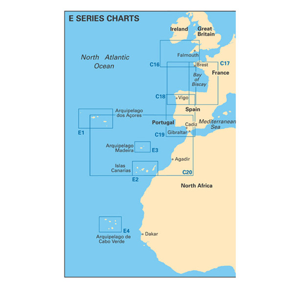
This Imray-Iolaire waterproof chart provides details of the Islas Canarias (Canary Islands) in the North Atlantic Ocean off the coast of Africa.
The chart is printed in color and includes insets of ports and harbors using official surveys and notes based on local knowledge.
It includes large-scale insets of Puerto de la Luz, Puerto de los Marmoles and Puerto de Naos, Puerto do San Sebastian, Puerto de Santa Cruz, Darsena Pesquera (Santa Cruz de Tenerife), Morro Jable, and Puerto de la Estaca.
Features:
- Printed in color on treated, water-resistant paper
- Folded for efficient storage
- Includes protective plastic sleeve
Specifications:
- Length: 34.5 inch (87.63 cm)
- Width: 25 inch (63.5 cm)
- Height: 0.1 inch (0.25 cm)
- Dimension: 25" x 35 1/2" (640 x 900 cm)
- Weight: 0.3 lb (0.25 cm)